Since the weather is starting to turn cold and the snow is looming in our future I thought I might do a post on warmer days where the sun was shine and the summer was just beginning. Early this summer I had an opportunity to visit Cape George and go hiking on the trails there and despite being a very beginner hiker I loved the trip and would do it again in a flash.
Cape George is a jagged tooth of land that sticks out into the ocean between Pictou County and Antigonish. To reach it you leave the highway 104 and turn onto the Shore Rd, also known as the Sunrise Trail. (The coastal highways in Nova Scotia were all labeled with names like this as part of an older tourism marketing campaign) Driving along the trail especially in the morning it is easy to see where the name came from. The ocean is a constant companion on your left side as you follow the road through tiny little communities like Merigomish, Ponds and Malignant Cove.

Along this route are plenty of other sights to see before you reach Cape George if you so wish. Big Island is a small island connected to the main land by a narrow causeway with water and beach on both sides. It’s a beautiful spot to stop and swim on a warm day. There is also a camp ground and several bed and breakfasts along the trail if you feel like it will take more than a day to explore. A little closer to the Cape you will come across Arisaig Provincial Park and aside from being another beautiful look off it is actually the site of some very old fossils dating back 400 million years ago. There is a small trail of about a kilometer and a half and a rest area making it a great place to stop for lunch. The trail winds through a wooded area and takes you past most of the features available to see at Arisaig. For more information on this park check here.
After about a 40 minute to an hour drive we reached the Cape. At the very point of it sits the Cape George Lighthouse and the beginning of the 33 km trails that cover the Cape. The lighthouse was built in the late 1800’s though the structure that sits there now is newer due to a fire that destroyed the original building in 1907. (It is actually the third structure to be built in that location.) Trail Head #3 is situated near the lighthouse but on the day we travelled there we actually started at the middle section, the trail from the lighthouse is a sinuous stretch of trail the winds down the hill and meets up with a series of looping trails. There are no branches off that particular section of trail.
As you drive down from the lighthouse you get a lovely view of the tiny town of Ballantyne’s Cove, it’s a small village surrounding a little marina. We decided to park at the marina since it was fairly empty when we were there. It was prior to the official opening season so we really only had to share it with the men that worked there. During the actual summer season there is a Tuna Interpretive Centre located at the marina as well as a fish and chip stand that apparently offers fantastic food. Beside the Interpretive Centre is a large board with a map of the trails and we were happy to discover little maps tucked in a waterproof box that were free to take. I would definitely recommend taking one; the trails can seem a bit confusing while you’re actually on them.
We checked all our “gear” though I use the term lightly because we certainly had nothing professional with us. We had a small back pack filled with light snacks, lunch, water, bug spray, sun block and our camera. I can tell you right now we did not have near enough water and usually this wouldn’t be a problem because there are fresh water springs located in a few of the rest areas. Since we arrived so early in the season the group that manages the trails hadn’t been out to do any maintenance on them and when we reached the first one we found no water was coming from the pipe. Always, always, always make sure you bring lots of water!

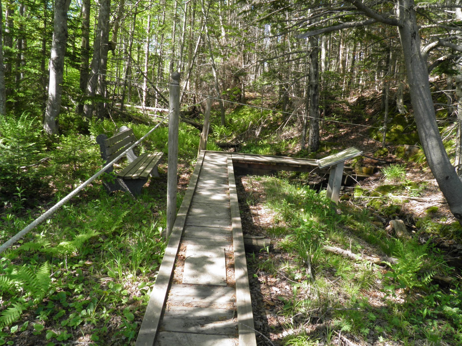
Once we decided we were ready to hit the trails we consulted the map, Trail Head # 2 was located down a short path directly across from the marina’s drive way. We stopped at the beginning to take a picture of the start which was a small foot bridge over a trickling creek and a bench (in case you were already tired?). It was the kind of moment where you psyche yourself up saying “No turning back after this” for me it was a pretty big deal because I have never done any real hiking. I have gone on walking trails through the woods or used atv trails but the Cape George trails are mostly footpaths through the woods rarely wide enough for more than one person to walk along them.
From here we dove into the woods and officially began our hike. We walked maybe 10 feet before the trail took an abrupt turn uphill, something I failed to take into consideration was the fact that Cape George is essentially a very large hill of which we were starting at the bottom. We made it through the first stretch and got a small break as we followed a path alongside a field filled with pretty flowers. My fiancé took advantage of my slower pace by running off and taking photos of everything.
 I should mention all the trails are marked with letters. There are 14 trails marked with A to N and should you feel ambitious enough there is a local challenge to get rubbings of all the letters. We didn’t attempt this challenge on our first go of the trails; this excursion was more of an exploratory one. After leaving the path by the field we followed what looked like an atv trail up until we met with a dirt road the cuts over the Cape from one side to the other. The map has you follow this road for a short period until you come across a small rest area with benches and you may have guessed the dried up spring. I already needed a short break to catch my breath at this point and it was probably only 2 km or so of trail. Next came my least favourite section, I call it the death hill.
 Just past the rest area beside (I believe) a community hall or fire hall the trail resumes in an uphill fashion. You travel through the woods for a short while and come out at another atv trail, it actually looks more like a gravel service road. It was very wide and completely exposed to the sun and a very steep, very long incline. I thought about half way up I would quit but I wasn’t about to let this hill win, my fiancé thinking he was being funny took a photo of me trudging up this beast.
Finally we hit the top and the trail veered back into the woods and to a bench, I was never so happy to see a bench in my life. I took a quick rest here and drank some water and we kept going. The path continued upward and then out over a gravel pit. The gravel pit was not the nicest site but looking past that the scenery was breathtaking (and not just because of the exercise). From this spot we could see right out to the marina and along the coast. I made the entire uphill journey completely worth it. From here we followed a few more junctions to a surprisingly well kept picnic area. It had a sturdy picnic table and a garbage can and some beautiful blossoming trees. We used this spot to eat our lunch and take about a 20 minute break before setting off again.

 The next few sections were mostly downhill with a small inclines. It was clear we were now heading back down the side of the hill and at one point not far past the picnic area this became very apparent. We came across a section of trail that literally went down the face of a small dirt cliff. A dirt path had been formed along this very steep decline that wound back and forth across the face of the hill. The only thing there for protection were a series of ropes strung between wooden posts along the edges. Needless to say it took me a while to get down, I was a tad scared about slipping down the hill but once I got there the rest of the hike was very pleasant. The path started following the edges of a small brook and eventually came out in a second picnic area. The area actually has some history to it and there were spots from interpretive panels but again we were too early in the season and they had yet to be set up. It was quite a wide cleared area and would have made a great place to camp if you are a rough it kind of person.
It wasn't long after this that we finally reached Trail Head #1 which comes out near the Cape George Heritage School. It is a small museum visitor can go see while in that area but of course it wasn’t open either. At this point we had hiked about 8km of trail and I was just about spent and we were just about out of water. Also as much as I wanted to see more of the trails I had to take into account getting back to the car. It turned out to be another 4km walk back to the car along the main road in the sun; the only benefit was a nice breeze blowing in off the ocean.
We made it back to the car in and I made sure to stretch before sitting down. I had that achy feeling in my legs that warned me if I sat still for too long I would have major cramps later. We checked the time before leaving the marina and realized it was just after one in the afternoon. We had arrived in Cape George around 9am. All in all our hiking adventure took about 4 hours. Had we been better prepared I think we easily could have spent the rest of the day there.
My only disappoint regarding the trip was that we went at the very end of May; the day before the season started. I would really like to return when everything is open and experience everything the Cape has to offer. Also I think I would like to return and do the trip with a larger group, I think it is an adventure that would be a lot of fun with a group of friends. I also wouldn’t mind returning in August when the group that manages the trail has their annual fundraiser, which I believe is a hike-a-thon. I think it is an event that would be a lot of fun to participate in.
Overall if I were to rate this experience from 1 to 10; I would probably give it a 7. The only reason it has a lower rating is because nothing was open when I went which is more of a lack of planning and research on my part than anything else. In my opinion the best part of this trip was that it sparked an interest in a new hobby involving the outdoors and physical exercise. I plan on exploring many more of the amazing trails Nova Scotia has to offer next summer, including a return trip to the Cape. I really hope some of you have the opportunity to try these trails out even if you are a beginner they are worth the work and achy feet. Next time you’re looking for an outdoor activity check out this hidden gem in Nova Scotia!
To see more photos check out the full album on my Flickr!
As always leave a comment or feedback on the writing, thanks so much for reading!
Total Word Count: 5161
No comments:
Post a Comment